Okay, so I am doing an interim publish because it looks like I will run out of time to get this leg fully finished before we leave Weipa tomorrow morning. Hopefully this morsel will keep you all interested for the moment.
Cheers
Doug
To the Lions Den
The day before starting our northern sojourn on the 30th of May, we rendezvoused for lunch with the folks who were going to be our traveling companions for the next four weeks. We’d previously met Prue and Max Borrows and Liz Kemmis and Graham Hanna at an Ultimate owners get-together when we had to take Ulysses back to the factory in Moruya for some TLC. A plan was hatched at that time to take a trip together to Cape York and grew to fruition over the intervening eight or so months. Our meal together on the waterfront in Cairns was a great way to reconnect before setting off the next morning. Here’s a photo of the six of us, anticipating our upcoming adventure:

Our plan was to meet 75 km north of Cairns at Mossman and continue on in convoy from there. Di and I stopped at a lovely little cafe at Ellis Beach for breakfast:

Not bad for outdoor dining at 8:30 in the morning, eh!
Just after that photo was taken, Max and Prue came by, saw us parked and joined us while we finished our meal. On to Mossman where we caught up with Liz and Graham for morning tea. Here is our convoy all lined up at the little park on the northern edge of town:


As you can see, right from the first morning the blokes on the trip were ready to take their responsibilities of exchanging ideas about vehicles seriously...

... well, maybe not all of us all the time:

Mossman is a lovely little town. There is a gorge nearby with wonderful swimming. It would make a good base if you wanted to spend a few days exploring the southern part of Daintree National Park as far north as Cape Tribulation. And the street-scapes feature beautiful trees like this one, that are like a world of life unto themselves...


Mossman is a lovely little town. There is a gorge nearby with wonderful swimming. It would make a good base if you wanted to spend a few days exploring the southern part of Daintree National Park as far north as Cape Tribulation. And the street-scapes feature beautiful trees like this one, that are like a world of life unto themselves...

It's all very well to hang around talking FourBeFour, but we needed to get moving so next it was on to the little village of Daintree, where it commenced to rain. It's a compact little "business area" with a feel all its own. This montage of three images on the public loos give a bit of an idea of where the locals are coming from ...

... as does this one of the Big Barramundi:

Affectionately referred to simply as "Barra" by inhabitants of northern Australia (and us southern pretenders, of course), Barramundi are regarded as one of the premier sport and eating fish in this part of Australia.
Apart from having a look at this little town, one reason for calling in to Daintree was to enquire about the state of the Bloomfield Track before catching the ferry across the Daintree River so we could proceed past Cape Tribulation - so named by Captain Cook for the difficulties he and his crew encountered there - and on to the Lions Den. We’d all driven the Bloomfield before. Although it has a bit of a reputation as a “proper" four wheel drive track, it’s a lot tamer now than it was in times past, but none of us had towed our campers over it so we were a bit keyed up as there are some pretty steep and narrow sections of road that would be a bit tricky were we to encounter oncoming traffic.
Upon arriving, we couldn’t get a definitive statement from people at the Daintree Information Centre on the state of the road north. Reports were rather mixed: from “okay if you take it easy”, to “some trees down in places but you can drive around them” to “pretty slippery in places”. There was no up-to-date report available from the road authorities for conditions on the Bloomfield and no clear indication of how much rain had fallen along the route. Faced with the choice of catching the ferry across the river with the strong likelihood of finding very tricky if not dangerous conditions and having to come back across the river - paying another ferry fare - backtracking to Mossman and taking the Peninsula Development Road (which is the regular route for traffic heading north) - we opted for the latter. As we travelled this more inland road we could see lots of very wet-looking clouds out towards the coast and decided that we’d made the right decision.
When we eventually arrived at the Lions Den ...

... Di and I smugly opened Ulysses up and unpacked the canvas while the others flipped their lids (NOT figuratively speaking) and erected their soaking wet canopies. Actually, while we’d all prefer packing and setting up dry it’s not really difficult or even very unpleasant packing up and re-erecting a wet Ultimate.
Although the roads travelled hadn’t been at all dusty we then completed the ritual by repairing to the pub for a cleansing ale, where I had a chat with a bloke who seemed to be a bit of a fixture. I asked if he was working on the road. He said he would be if the rain would stop long enough. That was a pretty good indication to us that we’d done the right thing in taking the inland route. We all had a pub meal that night and repaired to our campers, somewhat disappointed that we weren’t able to start our trip in style via the Bloomfield but, given the rain that had fallen, relieved that we’d checked road conditions and opted for the cautious approach.
Later that night it started raining pretty heavily and varying intensities of downpours continued off and on through the night. This little video will give something of an idea of what it was like the next morning when we were contemplating packing up and hitting the road:
Shortly thereafter the rain eased to a slight drizzle so we decided that it was a “Carpe Diem” moment, and raced out to pack up. And we all just about made it before the next heavy shower arrived!
Cook’s Town and environs
We planned to spend two nights at the Endeavour River Escape just north of Cooktown (named for Captain James Cook, who spent time here while his crew repaired the Endeavour) so we could have a day and a half to explore this historic village and surrounding places of interest. Along the road into Cooktown is a small National Park called Black Mountain. It is a striking place as you can see from this photo:

Basically, Black Mountain National Park is actually a couple of monolithic pieces of granite that have fractured into massive piles of very large boulders. Apparently the cores are still intact, but you wouldn’t know it from outward appearances.
On we drove to the Endeavour River Escape, a property that has set up a really nice campground to augment income from running beef, growing passionfruit and breeding Clydesdale draught horses. As soon as we arrived Di jumped out of the car to take a photo of a family of Radjah Shell Ducks - a new species to add to here collection of sightings- floating on a beautiful lily pond:

(At this point it’s important for me to acknowledge the massive job that Max did to research and organise all our bookings for us. Without his efforts we just wouldn’t have been able to do a lot of things that we wanted to on this trip. So, from all of us, thanks heaps Max!)
After settled in to our campsites one of the first things we did was take a walk down to the river to see if there were any crocodiles about. Just so you know, Di and I are on Croc Alert, anticipating our first sighting and trying to avoid Serious Injury or Death:

No crocs sighted, we headed into town to have a look at a few of the local attractions, including the powder magazine dating from the Palmer River gold rush days, and a trip up Grassy Hill to see the lighthouse ...

... where the lighthouse was built and Captain Cook took a number of walks to survey the reefs while his ship the Endeavour was undergoing repairs to its hull. The view over town and the Endeavour River estuary isn't bad ...

Then it was back to town to say hello to a miner heading for the goldfields ...

... play on the musical boat ...

... and check out this derelict dugout canoe ...

Because of the situation with the Bloomfield Track the previous day, Max had a suspicion that we might have difficulties further along our intended route, which would take us through Rinyirru (Lakefield) National Park via Kalpower Crossing where we had a night’s accommodation booked at the National Park campground. (Queensland National Parks regulations stipulate that park bookings must be made in advance. Max’s efforts in sorting our itinerary and pre-booking parks campsites had been massive, so this was a significant setback - and he’d already re-arranged this booking twice as information he’d received at one stage after making a booking at Kalpower showed the road to Kalpower was closed, and then re-opened.) Not only that but Rinyirru is one of the major highlights of the southern part of the journey to the Cape, noted for its birdlife.
Sure enough, when he rang the local Parks Office Max discovered the road was open as far as the Crossing but would be closed from there onwards until two days after we were due to go through. Going to Kalpower would involve backtracking southeast 91 kilometres to the Old Laura homestead and then turning directly south for another 27 kilometres before joining the Peninsula Development Road. Definitely not the way we wanted to go. Max had a brief discussion with parks personnel about opening the road early as the roads seemed to be drying fast but they said there was nothing they could do as the opening and closing of roads - including sections through National Parks - was done by the Cooktown Shire Council.
Max took a trip down to the Council offices to see if he could persuade them to open the road a couple of days early for us, unfortunately to no avail. That meant that our booking at Kalpower - for two nights, mind - was useless. So, Max rang Parks again to negotiate transferring our bookings, He had a long, long conversation with a number of different people who presented him with a number of positions, but the common theme for the first half hour or so was that we would lose our booking fee. (Work this one out: apparently regulations state that if you make a booking more than two weeks in advance - which must be paid for at the time - and then cancel, you lose your fee; but if you book within two weeks of your intended stay but then cancel you get your money back! Hmmm. Methinks someone in the upper echelons of the Queensland National Parks Service has been watching too much “Yes Minister ...) This is already a long story, so to cut it short suffice to say that Max patiently waded through the bureaucratic mire and managed to get at least some of our booking fees credited towards a booking elsewhere.
Next day we drove southeast to Archer Point, where another lighthouse once operated ...

... and gun placements were situated during World War II. Also in evidence are the remains of an old wharf used for landing supplies ...

... which would have come from Brisbane to the south. Just offshore is a shipping hazard by the name of Rocky Island, which has its own little light ...

One thing that was new for Di and I but perhaps not the others was the sight of those big turtles feeding just offshore. There were a few of them, and it was a bit choppy to get a real good look, but it excited us none the less and was another indication that we were really are now in the tropics.
Graham then led us to Trevethan Falls which he’d visited on a previous trip, which was lucky because this lovely little gem is well hidden away off the beaten track. Whereas there were about a dozen other people at Archer Point while we were there, we had the falls all to ourselves ...
Graham then led us to Trevethan Falls which he’d visited on a previous trip, which was lucky because this lovely little gem is well hidden away off the beaten track. Whereas there were about a dozen other people at Archer Point while we were there, we had the falls all to ourselves ...

This tree spanned most of the stream below the falls ...

... Max took off his shoes and socks in search of the perfect shot ...

... and here's our prize: a view of water tumbling down into a secluded pool:

Back on the track to our vehicles I got this snap of an (Australian) Mistletoe flower ...


Next stop was Keatings Lagoon, just outside of Cooktown, to see if any birds were about. Unfortunately, it was a bit early in the year for this place which is normally teeming with waterfowl. Apparently, the birds tend to congregate here when other places have dried up. Still it was great to get out of the car and stretch the legs again. These photos of Di's will give you a bit of an idea of what the place is like:


On to ... where?
With the removal of Kalpower from our itinerary we had no fixed place to spend the night, so the plan was to set off and stop wherever we felt happy. An interesting and very pretty drive took us past Endeavour Falls ...

... and the lovely little Tourist Park here (completely empty when we passed through) would make for a pleasant overnight another time. A little further along we crossed a creek and got out to photograph yet another lovely cataract ...

... and I found this little seedling sprouting straight out of the side road which used to be the main route before the old bridge got washed away ...

On via Battle Camp Road to the Old Laura Homestead, a short 100 or so kilometres from our previous stop at the Endeavour River Escape. Here's a "bum shot" (climbing terminology for an unflattering photo taken from below a lead climber that basically just shows their rear end) of our three campers, taken when we arrived. The main reason for taking this photo is to show our states of origin. If you look closely you can distinguish plates from Queensland, Tasmania and New South Wales ...
This historic station established to supply beef for the Palmer River gold rush and is something of a mecca for folks traveling through this way. While there Di also positively identified three new birds: the Forest Kingfisher, the Rainbow Bee-eater and the Olive-backed Oriole. Sorry, no photos at this time. However, you might enjoy a few snapshots of what's left at Old Laura, like this one-blade plough made in Chatanooga Tennessee ....
 |
| A trio of handsome backsides? |

... this rusted out wreck of an old Blitz truck ...

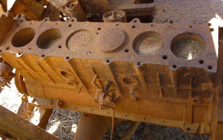
... and its straight six engine block ...
... an interpretative sign explaining the construction of the homestead ...

... and the homestead itself as it looks today ...

Because of the forced changes to our route we had a day to spare and were looking for an additional campsite before we reached Weipa. So, after poking around the homestead for a while and having morning tea we thought we might as well have a look at the site adjacent to the Old Laura station. The campsite is situated in the area where the old Chinese garden had been established to supply the station and passers-by with seasonal vegetables and fruit. It was a very nice spot, situated amongst ancient mango trees and Moreton Bay Ash trees so it was a no-brainer to kick back here for the afternoon ...

Taking time to savour the moment usually yields unforeseen pleasures, like a few extra hours to read a book, and unexpected discoveries, like this bird's nest Max found lying on the ground ...

Laura and Haan River
Our trek towards the Cape continued the next day with the short drive to "new" Laura, where an old tractor was parked amongst some picnic tables across from the shop. Here it is with our "tractor" and camper parked in the background ...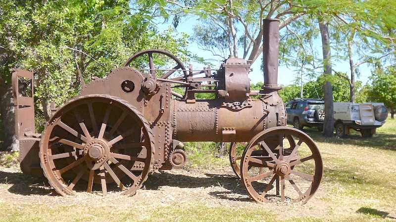
This is an important centre for the world class Quinkan rock art, and the Quinkan Cultural Centre in Laura does a great job of interpreting the local Aboriginal connection with the land as well as European history in the area. We spent a couple of hours looking around and then went out to the Split Rock art site. A $5 fee allows access to three small galleries that give a taste of the concentration of art works in the area. Time and budget considerations permitting, we may take a more extensive tour on the way back south. This is the sign that greets you at the start of the walk up to the galleries ...

Out of respect for the stipulation on the sign that no videos or cameras are allowed in galleries unless prior arrangement has been made, I don't have any pictures of the artwork to share at this time. Unfortunately, not all visitors show the appropriate respect for the Ang-Gnarra Aboriginal Corporations efforts to make these galleries accessible at a small fee ...

It's only a short walk up a hillside to these three galleries and it's well worth a visit on your way past. Lot of layering has taken place over various periods of time and it's very interesting to see different images covering others from previous eras. To give a taste of the setting of the galleries I did take a couple of photos along the way showing the boulders where the Flying Fox gallery ...

... and the Split Rock gallery are situated ...

Haan River is another significant river crossing at which there is a roadhouse and a campground. Camping was quite nice and you could walk down to the river for a bit of a look but like every other such place, swimming is not advisable. Di’s description of the amenities block at Haan River could be summed up in one word: “rustic”. And it was, but - despite appearances - the very basic-looking shower proved to be just fantastic and far better than you get in lots of modern hotel rooms. A neat little highlight of the place was that an emu, a peacock and a kookaburra all fairly nonchalantly visited our campsite during the course of the late afternoon and again the next morning ...


The Archer River Run
After leaving Haan River, the first place of importance one comes to is the Musgrave Roadhouse, where Saltwater Creek is crossed and the route we intended to take to this point comes in from the east and Kalpower Crossing through Violet Vale. (Were you to continue west on this road rather than turning north on the Peninsula Development Road you would go through Glen Garland. I was a bit taken with the alliteration of those two places.)
Saltwater Creek is crossed just before arriving at Musgrave Roadhouse and this is what it looks like ...

Many of this tiny but important way stations have got a headstone or a commemorative plaque honouring a significant local identity, sometimes tucked away somewhere but more often than not in a prominent position so that travellers can pause and ruminate on the contribution that person made to the local community. Musgrave Roadhouse is no different ...

You get some idea about how far you are from various places on the Cape York Peninsula. Bear in mind that most of this travel is on gravel roads, often in fairly ordinary condition ...

On the topic of road conditions, it might seem that we would be sorely disappointed in not being able to travel on the Bloomfield Track and through Kalpower Crossing (and Violet Vale), while it was something of a let-down the trade-off was that the condition of the roads that we have been on has been wonderful. We are right at the start of the season for the Cape and road crews are busy grading and fixing up dodgy bits. Max and Prue keep saying how amazingly smooth the roads have been. We've been exclaiming "more Silk Road!" often as we have emerged from a short section that hasn't yet been graded.
Anyway, back to Musgrave. This old fuel bowser gives some idea of how long the roadhouse has been supplying motorists with what they need ...

We saw the interesting sight of a couple of brand new off-road camper trailers being off-loaded from a semi-trailer ...

They were from online campers.com.au and were about to be taken on a trip with some four wheel drive magazine or other. And then of course there is the Ultimate ...

We were starting to see more and more ant mounds along the side of the road and decided to stop at one spot to take some photos ...

It's very interesting to get up close and personal. The ants are busy cutting and storing grass inside the mounds for when the wet season comes. Here's an image showing an ant stuffing a bit of grass into a hole in the surface of the mound with the assistance of a companion ...

... and this next image shows some major teamwork to shift a relatively big bit of grass ...

The last place of interest before reaching our overnight stop at Haan River was the small town of Coen. And of most interest is the gender-bender pub the locals have at their disposal ...

We stopped for lunch beside a pretty little stream just the other side of Coen, and then as we were approaching the Quarantine Checking Station spotted a burnt out semi-trailer on the side of the road ...

... which was a sobering sight as we neared the end of our day's journey at Archer River ...

We arrived reasonably early and set up camp. Lots of people arrived through the afternoon, but it never got to feeling crowded ...

This entire campground has been underwater during various big floods cause by tropical storms. The amenities block, which is above and beyond the campground shows previous flood peaks ...

Again, there was a plaque attesting to the character of a local identity ...

Lots of families with young kids are on the road, exploring the country. Here's some little'uns feeding the horses ...

After another interesting day on the road we relaxed with a cold drink and a few nibbles ...

Up at the roadhouse there is a sign letting folks know where they can and cannot take alcohol ...

We all decided to partake of the famous Archer River Roadhouse burgers for dinner. Di decided the pick of the crop - the actual Archer Burger - was just the ticket for her appetite that night ...

The next morning Di and I wandered down to the river before we set off for the day. I thought this photo of Di next to the water gauge at the crossing might give readers some idea of what levels could look at various times ...

... and this one I snapped in a hurry surely gives an idea about why you need to be paying close attention when you sense a road train is a-comin' ...

Into Weipa
After a number of very interesting days, the run into Weipa was relatively humdrum. We did stop at some huge ant mounds for morning tea ...

... and Di snapped this quite good photo of a Black Kite, showing its distinctive forked tail ...

That's about it for now. Hopefully I'll be able to add a bit about our stay here in Weipa before I put up the next post. In the meantime, here's a map of the latest section of our journey (not quite accurate, because Google Maps wouldn't let me route through Old Laura) ...

... and an overview of this stage in the context of the overall journey, with our starting point of Hobart way down at the southern end of Tasmania marked with a red dot?


Almost there! Cheers for now ...