We have covered a bit of territory since my last post. As the main reason for our visit to the North Island was to spend a bit of time with our grandchildren, perhaps a first up photo of Di with them would be appropriate ...
After leaving Gilgandra we made a beeline for the Queensland border so we could be close to Brisbane to pick up our little darlings. A search for camping not too far from Brisbane but also reasonably close to the Granite Belt of southeast Queensland yielded the Bigriggen Park, which boasts bush camping and a great environment for kids. We liked it so much when we arrived that we decided to book an extra night. Here's a photo of our camp set-up, with the kids' tent pitched under our bed (some might say a bit too close for comfort!):
The camping was great, with lots of room for the kids to run around.
We did one walk to the top of Mt Edwards from Lake Moogerah. Asha, full of beans, was the star of this walk, going to the top twice: once with me and once with Di. There wasn't a lot to photograph but I did make one picture of this interesting fungi which had grown around a leaf ...
From Bigriggen we moved to Stanthorpe for a couple of nights so we could visit Bald Rock National Park. (In retrospect we wished we'd gone to camp there, but we couldn't get any info on the camping and we thought, like the campgrounds at Giraween, it would be full during the school holidays.)
On the way through the Border Ranges we stopped for lunch at a little town called Bonalbo, where the kids also burnt off a bit of energy stored up in the car ...
Our little hike to the top of Bald Rock was fabulous, with wonderful views on a stunning spring day. Here's a photo of Di and the kids near the top of the peak ...
On the drive back we passed this amusing sculpture ...
A fantastic wind had come up by the time we got back to Stanthorpe so after lunch we got out the kids' kites and flew them both right out to the end of their strings. Asha and Zae were just a bit nervous about the kites being so high in the sky so we reeled them back in before they vanished into the stratosphere.
The next day we shifted to Girraween, where we had managed to snag just a couple of days at the end of our week with Asha and Zae. It was a scintillating day when we arrived so we wasted no time getting camp set up and then walking to the top of the Pyramid and back. We took a few photos along the way, but my favourite is probably this one ...
On our last full day at Girraween we hiked to the top of Castle Rock and then along to have a look at Turtle Rock. Although it was a bit showery and cool, the kids didn't complain at all and we had great fun scampering to the top of Castle Rock and tip-toeing back down dodging the puddles. As you can see if you look closely at the next photo, the spring flowers are starting to come out ...
The irises are especially beautiful just at the moment ...
After dropping the kids back at the airport we stopped in at Scarborough for a visit with our friends Max and Prue, enjoying dinner with them and their extended family. The next morning before leaving we went for brunch with them and Nev and Dot, who were also down in Tassie last summer for a "rendezvous".
While it would have been nice to join Max and Prue for an upcoming camping trip we really wanted to start our slow journey south and do a bit more riding in new territory, so we headed off across the border to Kingscliff. We had a terrific ride there through some lovely rolling terrain. You know you can only be in Australia when you see signage like this ...
Yesterday we moved further south to the quaint little town of Bellingen, where we are currently camped in the showgrounds. Today we had a very interesting ride. Some quite rough sealed roads; a bit of dirt; despite no long hills, quite a lot of up and down and then, finally, a lovely descent back into the heart of the town. Here's a photo of Di getting to the top of one of the hills on the gravel section of our ride ...
... and another of her relaxing back at camp reading a novel on the iPad ...
We hope to do another ride in the morning before leaving to head further south to our friends Graham and Liz in Bonnells Bay. The weather looks good, let's hope the legs are willing.
Here's a map showing the territory we've covered since our last post ...
We're not quite sure exactly where we're headed after Bonnells Bay, but we'll be in wonderful Wagga Wagga in a week and a half. How we get there remains to be seen ...
Well G'day. It's been a while since Cockatoos and Kangaroos has had an airing, but here we are.
It seems fitting to be making a post in this blog when we are on the road again with the Prado and the Ulti, on our way to pick up the grandkids for a bit of exploring in the backblocks of southeast Queensland. Hopefully we will be able to share some iconic Australian landscapes with them and have an outdoor meal or two, although - as we are not going to be on the coast - we probably won't throw on a shrimp on the barbie! Besides, it isn't actually summer yet so not technically barbecuing season.
After leaving home in Hobart at about noon on Sunday and then stopping to visit Pat and David in their new home in Longford, we rolled on to spend the night in Devonport before catching the morning ferry to Melbourne. All sweet until the silly sausage who checked our vehicle decided that the smaller of our camper's two gas bottles needed to come out of its secure storage locker and go on the trolley for us to pick up at the other end. Unbelievable. We've been back and forth on the ferry with the camper perhaps a dozen times and never had anyone query this before. The officious little person gave the official reason as "all gas bottles must be held in place by a metal bracket". So this is what we have in our gas locker ...
Secure or ... not secure?
As far as I know, none of the 40 or 50 Ultimate camper trailers that visited Tasmania last summer had to surrender their gas bottles for transport and, as I said, we've never had this happen before. Just another little bit of silliness from a small person with a very small brain. (Compared with all the other trips we've made over the years with camping gear stuffed into the car and always having to stop when we get off the ferry to pick up a gas bottle, up until now travelling with the camper-trailer has been sweet in this regard - which is why I was particularly annoyed this time around.) What made it all even more silly was the person with the official coat on did not insist that we had to surrender the big bottle, which has the same sort of restraint system as the tiny bottle. Why not, I wondered (but not aloud: didn't want to get the small brain working too hard!)
Landfall and beyond
This was our first ever day sailing on the Spirit of Tasmania and we had a general - but untested - plan of "What to do When We Get Off the Boat". The ferry arrives about 6:00 p.m. We wanted to clear Melbourne and get a bit of a way up the road so we could reduce - if only slightly - the amount of driving we would have to do each day for the next four days to a base from which we would sally forth to the Brisbane Airport to pick up our darlings. We've got the bikes with us, and our hope is to be able to have a ride after driving each day.
So far so good. Here's a map showing where we've got to so far: two days after landing in Melbourne and our target for midday on Friday ...
We got a couple of hours and about 170 kilometres up the road to Euroa: just in time to check into a motel (it was raining) to watch the final episodes of both Vera and The Bletchley Circle on our beloved ABS.
Now fully debriefed and ready for a month on the road - although I will at least have to find a pub to watch the AFL Grand Final - we set off yesterday morning with a vague plan to drive about 400 kilometres, find a caravan park and then go for a ride, then repeat a couple of times. Oh yes. We also wanted to drive some roads that we'd not been on before and visit some previously unvisited towns.
The First Stop is the ... Sweetest?
With Di looking at the road atlas as I drove, we cobbled together a route and fetched up a bit after midday yesterday in Young, which lays claim to being the "Cherry Capital of Australia", a boast that several places in Tasmania would find somewhat bemusing. It was a bit cool, but we really wanted to get back on our bikes after a pretty hectic month without much time turning the pedals so, after setting up the camper and changing into our cycling gear, off we set.
Now, Di hasn't been on the bike quite as much as me since we finished our ride from London to Rome so we were playing it by ear as far as the distance we would go. It was a bit cool and we only had a couple of hours of daylight left so ended up doing a shorter ride than we might have liked. Here's a photo of Di, stopped to put on her headband for a bit of extra warmth ...
A typical Aussie outback scene: gum trees and canola
Going Deeper into New South Wales
Without really planning it, our drive over the past couple of days has taken us through some historic places. Before arriving in Young yesterday we passed through Cootamundra, the birthplace of "Our Don", otherwise know as Don Bradman, the cricketer with the fabled batting average of 99 point 9 something (light years above anyone else in the history of the game). And today we passed through Grenfell, the birthplace of the great, but seemingly almost forgotten by modern Australia, colonial era poet, Henry Lawson. This is goldrush country and many of these towns boast a faded grandeur, thanks to the legacy of the precious ore extracted from the creeks and rivers that wend across the landscape.
During today's drive from Young to Gilgandra we passed through country that has had a lot of rainfall over the past few weeks. With the terrain hereabouts being generally fairly flat, when it rains a lot the water tends to wander a bit resulting in widespread flooding. We crossed through a number of spots where there was water across the road. Here's a video of one of those crossings, that Di shot through the windscreen of the Prado ...
Despite being slowed numerous times by these aquatic incursions, we managed to arrive in Gilgandra reasonable early in the afternoon, set up camp and set off for another ride. (Two rides together in two days: yippee!) Even on our ride, where we found a quiet road off the highway, we crossed several small watercourses across our path. There sure is a lot of water about. Which of course means that there will be a large upsurge over the spring and summer ... Of Cockatoos and Kangaroos! And with that I bid you all a good night ...
When we decided to push northwards from the Flinders Ranges and visit Chambers Pillar, Di said we might as well spend a bit more time and visit the iconic destinations to the west of Alice Springs, most notably Watarrka National Park and Uluru - Kata Tjuta National Park. Within the first of those two parks lies the famed Kings Canyon; the second is of course famous for what more recent arrivals in Australia have called Ayers Rock and "The Olgas". Our travels in that area proved to be amongst the most rewarding of our trip to the mainland and we are rapt that we extended our stay and made the extra effort.
Here's a snapshot of the journey we made to get from Chambers Pillar to Uluru ...
This kind of looks like a virus, don't you think?
Uluru wasn't far out of our way ... just aboutone thousand, one hundred and eighty-eight kilometres!
Watarrka National Park
We arrived at Kings Canyon Resort late afternoon and were delighted to discover that our friends Max, Prue, Graham, Liz and Neville had also found their way to Watarrka. We settled into camp beside them and proceeded to share stories of where we'd been and what we'd done since leaving Chambers Pillar. It turns out that while we'd been to Hermannsburg and the West MacDonnell Ranges, they'd visited Lambert's Centre of Australia.
Undoubtably, the highlight of Watarrka is Kings Canyon, and the main focus of that feature is the Kings Canyon Rim Walk. There is also the shady, short and pleasant Kings Creek Walk that is worth doing. Kathleen Springs is another sacred site for Aborigines; the canyon leading towards the springs was used for mustering cattle 150 years ago and is one of the places where the skills of Aboriginal stockmen came to the fore and were highly valued by early pastoralists. A walk we didn't do because of time constraints is the Giles Track, which wends its way across the top of the Giles Range for 22 kilometres from Kings Canyon to Kathleen Springs. If you're visiting the area sometime and like walking you might want to allow yourself time to do this challenging hike. You'll need to organise a car or bike shuttle and an early start to beat the heat would be advisable!
As I said earlier though, the Rim Walk is the highlight of the park and not to be missed. We think it's definitely world class (and we've done a bit of hiking in various places over the years), and National Parks in the Northern Territory have done a fantastic job in making this walk accessible for any reasonably active person. You don't need a super level of fitness as there are may spots to rest along the way. Indeed, on the initial slope - which does climb fairly quickly - there are several benches strategically placed if you need them, which allow you to get your breath back. And it's definitely not a walk to rush through: you will want to linger and savour the many stunning views to be had. What really surprised us were the hidden oases along the way and the amount of vegetation - much of which was in flower thanks to recent healthy rains. Hopefully the following photos will give you some small appreciation of what we experienced.
A pause up the initial slope gives just a hint of the pleasure to come ...
Up on the rim, we started to appreciate some of the beautiful rock formations ...
As I mentioned earlier, there were lots of plants in flower. Here is a study of a cache of blossom that has fallen from a large shrub ...
There were plenty of Fire Sida in flower too ...
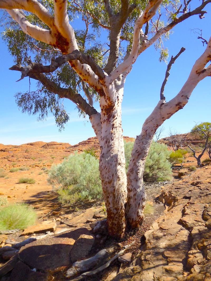
We were delighted to see that a few Coolabah trees surviving - indeed thriving- on the rocky rim, including these two beauties ...
The walk is ostensibly 6 kilometres long, but it would be a pity to miss the side trips to a couple of lookouts and the detour into the amazing Garden of Eden, a true oasis that you drop down into about halfway through the hike.
Here is a photo of one of the stunning faces that you will see if you do take one of the side trips ...
Looking back along the plateau, you can see that Di is clearly delighted with the terrain we've been through. Our new mate Neville trails behind ...
... spotting wildlife for Di to photograph ...
The light and views that we enjoyed on this hike had us in raptures, and textures in the landscape added enormously to our appreciation of this fantastic environment ...
Being something of a tactile person, I couldn't resist coming to grips with the rock ...
This gnarled old Callitris had obviously been around for some time ...
Long before we were able to descend into the Garden of Eden we got a glimpse of it from above. The photo doesn't really do justice to the position you're in or where you're going to be if you do the side trip, but it's the best I could do ...
A bit further around you get another perspective on that great rock face you saw earlier, this time with a better understanding of the angle ...
About halfway around the walk there is a descent on a series of stairs below an overhang ...
Below, we discovered our friends Graham, Liz, Max and Prue taking a breather and enjoying the good life ...
Beam us up, Scotty ...
At about that point there is a bridge to cross over a bit of a chasm ...
... which featured a range of shrubs and small flowering plants, as well as Coolabahs and Cycads. It's actually possible to scramble off the track and down into the chasm, which we did. We were rewarded with a look this fungus growing in the cool and narrow lower end of the chasm ...
A little further before dropping down into the Garden of Eden you get this view of lushness ...
Di made a lovely photo of the Coolabahs and Cycads reflected in the still, deep pool ...
Here's another view ...
It appeared that there was a lot more water than is usually the case ...
This place must have been a wonderful sanctuary to the Indigenous people that lived in and around the area.
Back up on the rim, there was another species of shrub absolutely covered in red and yellow blossom, which Di dubbed the "Burning Bush" ...
I discovered this feather caught up amongst some grass ...
Further along the way you will come across this wonderfully textured old Coolabah ...
Nearby, in contrast to the might of the Coolabah I found this precious flower ...
The last view of the Canyon I'll share with you is this one looking back towards the early part of the walk. If you look closely you should be able to count five people scattered along the trail, which gives a good sense of scale ...
Hopefully the photos above will have given you an inkling of the diverse delights that are to be had if you undertake Rim Walk at Kings Canyon. It is possible to take a helicopter ride over the canyon which would no doubt be extremely spectacular, but if you do please don't deprive yourself of the intimate experience of the Rim Walk. It will be something you'll remember for a lot longer than the ephemeral detached 15 minutes in the air that a flight will provide.
Uluru - Kata Tjuta National Park
ULURU or simply "The Rock"
Amazing. Spiritual. Awesome. Stunning.
According to this website, Uluru is the largest monolith on Earth, dwarfing the iconic El Capitan in Yosemite, the Rock of Gibralter, Devils Tower and other well-known humungus hunks of stone, although perhaps the term "inselberg" is a better one, as "monolith" is a bit ambiguous and often taken to mean a block of stone that has been moved, manipulated or erected by humans. And who knows ... when the ice cap on top of Antarctica melts scientists might find a bigger single piece of stone. Whatever. suffice to say Uluru is something to behold and, for the record, holds the current record.
Unless you take the easy way and jump on a plane, it's even quite an effort to get to Uluru, which I suppose adds to its aura: as one gets closer ... and closer ... the views change all the time and your sense of anticipation grows and grows.
Along the way
Long before you reach The Rock you are reminded of where you are and where you're going ...
The Red Centre Way with Kata Tjuta in the background
But before we reached the Red Centre Way we saw some camels on the side of the road just after leaving Kings Canyon Resort ...
... followed by a casual dingo shortly afterwards ...
... and then a small flock of Major Mitchell Cockatoos, including these two which let Di get quite close ...
It was a great morning's drive with lots of animals to look at, but of course what we wanted to see most was the fabled Uluru. As we drew closer and The Rock appeared, naturally Di kept wanting me to stop for a photo. The problem was that we'd get a glimpse and then a sand dune would get in the way ... and then there wasn't a good shoulder to pull off on ... and then another sand dune would get in the way ...
Eventually, I did manage to find somewhere to pull off the highway and Di scrambled to the top of a dune and took her first photo of Uluru. Although it looks close due to the zoom, it's actually still a long way off ...
By the time we got to Yulara we thought that that we wouldn't see any more wildlife, but right inside the resort dingos were trotting around as if they owned the place. I'm including this photo because you can easily discern the classic markings of pure dingo, which are the "five points": four white paws and a white tip on the end of the tail ...
If your mind is closed to matters spiritual you might as well skip this bit. But if you think each culture has a right to be respected for its values and beliefs ...
... I hope you'll read on.
For the Anangu people, who call this part of the world home, Uluru is a precious and sacred place. Along with Kata Tjuta, it forms a Unesco World Heritage site. The information and maps distributed by National Parks make it very clear, as does the signage at the base of Uluru, that the Anangu people prefer one does not climb it, indeed to do so is hurtful ...
It felt like such a privilege just being able to see this amazing piece of landscape that it was an easy decision to respect the wishes of the Anangu people, and walk around The Rock rather than climb it. We hope you will be able to make the same decision if you visit Uluru in the future. You will view parts of the rock that those who climb probably won't, and you will be respecting the beliefs and wishes of the original inhabitants of this area, who still call this country home. Anyway, that's it for the soapbox.
Take a hike, Mike - or maybe two ...
If one isn't up to the full 10.6 km loop around the base there are three different spots close by that one can drive to and explore various points. This map from a parks brochure shows an overview of Uluru and where the access points are, with areas not for photographing shown in black ...
We set off in a clockwise direction from the Mala carpark and were immediately surprised by the amount of vegetation ...
Shortly after starting there is a detour to a beautiful waterhole, with a lovely seat - the first of several - along the wayside ...
At the waterhole itself the rock was shimmering in the afternoon light ...
After leaving this waterhole we passed a long section where it is requested one does not take photographs, so the next shot is around further to the north ...
As you may have noticed in the map the track moves well away from the base on the northern side, which is quite good because it gives you a full view of this amazing phenomenon ...
Uluru from the northern side, along Base Track
As we moved around and with the light hitting the rock from different angles and bits of cloud drifted across the sky the colour was constantly changing ...
Another view a little further along towards the northeast
Eventually we started to move closer to the monolith and began to enjoy a more intimate connection and appreciate some finer detail ...
... and some beautiful textures ...
Around on the eastern side the track took us right up close again to the base. Here, The Rock had gone into shade ...
More large erosion features appeared, first this one ...
... and then this awesome, gaping maw ...
A sheltered, vegetated corner that must have been a wonderful cool hangout for the Anangu people on hot summer evenings lay along the eastern side ...
That was about it for our hike. I'll leave you with the obligatory sunset picture of Uluru. When you've taken photograph after photograph after photograph, how do you choose a definitive one? Although obviously no comparison to the bazookas that some were pointing at the rock, even with our very simple cameras and rudimentary skills it's hard not to get at least one reasonable photograph of Uluru at sunset. Anyway, after a bit of eeny meany miny mo, here's what I chose ...
Kata Tjuta ~ la pièce de résistance!
An awe-inspiring destination in its own right, Kata Tjuta is very much overshadowed by Uluru, which is a bit ironic: at 910 metres, Mt Olga, the highest dome in Kata Tjuta, is 47 metres higher than Uluru. Kata Tjuta is made up of 36 separate conglomerate domes comprised up of granite and basalt rocks in a sandstone matrix.
You can see Kata Tjuta from a long, long way distant and the views of it just keep getting better as you get closer. Di got me to pull over when we were about 15 kilometres away and she made this panorama:
At about 10 kilometres distant there is a viewpoint overlooking Kata Tjuta called the Dunes Lookout, which we pulled into. On the way up to the viewing platform there is a little sign beside a juvenile Desert Oak. In the background you can see some more mature examples …
There was also some information about the Spinifex plant, which Aborigines used to make “bush superglue” …
Maybe one of the most rewarding aspects of spending sustained periods of times in an environment is the opportunity afforded one to become more familiar with the minutiae of that environment. It's easy to get the big picture with a quick visit, but that doesn't allow you to feel like you really know a place. We feel really lucky to be able to spend the time to learn more about the Red Centre and to have established a strong sense of connection.
Okay. Moving on. At the lookout, which is up on a raised platform, I made this short video with my little point and shoot camera …
After all we’d heard about Kata Tjuta we were really excited to arrive. It was another brilliant late autumn day in the Red Centre: perfect for a couple of walks. Here’s an overview map of the formations showing where the walks go …
I’m going to describe the two walks in the reverse order of how we did them, saving the best for last. First up,
Walpa Gorge
The Walpa Gorge Walk is a lovely, flat 2.6 kilometre return trip and well worth doing. Initially crossing a rocky stretch before entering the inner reaches of the gorge, the track gives way to a pleasant pathway and sections of boardwalk which lead to a beautiful permanent waterhole. It is another sacred place for the Anunga people.
The gorge provides a great little refuge for desert animals ...
Along the base of the rock, shrubs and trees crowd in, making the most of moisture that pours from the cliffs in wet times. In places, boulders lie strewn about, victims of gravity's pull ...
The head of the gorge is absolutely choked with with vegetation, providing fantastic cover for echidnas in particular. When we visited, many of the shrubs were in flower ...
Strange patterns of erosion near the base of this face put me in mind of a sinister grin, almost like a Halloween pumpkin ...
... or the face of some demented, ochre-coloured mummy ...
I mentioned before that we were most impressed with the quality of interpretation in all the parks we visited in the Northern Territory. The following sign details the uniqueness of the plant ecology in this ancient gorge ...
At the end of the walk, one is rewarded with the serenity of a quiet, sheltered waterhole reflecting the encircling domes ...
Past the waterhole is sacred ground, where people are forbidden to go but adjacent to the waterhole some lovely shrubs were in blossom, firstly this delicate, cupped Fire Sita ...
... and this exquisite flower ...
is the Striped Mintbush. Walpa Gorge is one of the few places it is found. Known for its medicinal properties, it can reduce cold and flu symptoms and dry out sores. And that's about it for the Walpa Gorge. Now for the main course ...
The Valley of the Winds Walk
When we told people that we were going on to Kings Canyon and Uluru after we left Chambers Pillar, we didn’t realise that Kata Tjuta was so close to Uluru, which just goes to show how little we know about the treasures of the Land Downunder. Our friend Graham said that it was a “must do” to visit this incredible place, and that the Valley of the Winds Walk was one of the most beautiful he’d ever done. The full circuit of the walk covers 7.4 kilometres. As one moves in towards the entrance to the Valley of the Winds this is the view to be had …
It was so captivating I couldn’t resist playing with the video button on my dinky little camera, so if you'll indulge me here's a short clip expressing a bit more than the thousand words' worth of a photo (sorry about the voice over) …
Back to still photography, here’s a short section of the track, wending its way between a couple of domes …
The next photo clearly demonstrates the nature of much of the surface underfoot along the walk, and is the same composition as the conglomerate rock that makes up the domes ...
The next photo looks back the way we came, about halfway through the inner part of the domes. The entrance to the valley is around the dome on the right of the photo …
… and this image shows where we are going …
Once out of the inner section of the walk views become more expansive. One of Di’s favourite domes was this one in the distance, because of the carpet of vegetation on the top she imagined it as some sort of shangri-la for small critters, safe from predators …
Here’s a shot detailing some of the domes looming immediately above us as we make our way …
After we’d had lunch and lingered awhile to enjoy the views at the northern most point of the track, where there is a lovely shelter and fresh water on tap, we headed off to do the last couple of kilometres. At this point the path finds its way between a stand of Coolabah trees …
… amongst which I found an absolutely beautiful flower, which unfortunately I have not yet been able to identify …
The wending nature of the Wind Valley Walk means that you get lots of different angles from which to observe the domes. Here’s another view a little further along …
This next shot is one of Di’s favourites because of the way it reveals criss-cross weaknesses in the rock, highlighted by the grasses that have taken root in the cracks …
For the last picture we’ve got to share with you from the Red Centre the slow pulsing heart of our beautiful country we’ve chosen this panorama that you will experience in the outer part of the Wind Valley loop …
Right at this very moment we are snuggled down in Mimosa Rocks National Park on the south coast of New South Wales, not far from the border of Victoria. Here’s a picture of the Prado and Ulti (with the bikes parked behind) nestled under a gorgeous spreading tree …
I can hear the rollers tumbling in on the beach below us. Tomorrow morning we’ll have a wander on up the strand before we set off southwards. Over the next few days we’ll ease our way down to Station Pier in Port Melbourne to catch the ferry home. As you can see from the next photo we’ve taken something of a detour …
Those of you who’ve been following the blog from its inception will be aware that we’ve had a few issues with our fridge. At Weipa in Far North Queensland. On the northwest coast in Tasmania. At Lake Natimuk in Western Victoria. Lake Mournpall in northern Victoria. Chambers Pillar. Actually, pretty much all over the place. We finally decided to cut that unreliable Dometic 3-way fridge (model 2355) loose and have put a new Engel compressor fridge - the gold standard of mobile fridges - in its place. Although the Ultimate factory in Moruya was rather out of our way we thought it best to get the folks at Ulti to do the swap over for us. We hope that will be the end of our fridge woes and we can have ice cream in the fridge the next time we head off for an Ultimate holiday.
Until then, all the best from
Doug and Di (Psst ... before you go, could you please complete the poll below for us? Thanks!)