The Boss and I had been discussing some trips we could do, combining a bit of riding, doing some Island Dreaming and making use of our Freedom Machine. A short trip we thought might be fun would be to do a bike/drive relay to Southport one day, have a hike day two, then ride/drive back on day three. On Monday evening, after having a look at the forecast Di said, "What about going to Southport tomorrow?" "Okay," says I, and we started packing.
Day One: Cycling Relay ~ Hobart to Southport
I asked Di whether she wanted to ride or drive first up. She said she wanted to ride down past Dover through to Southport, which meant that I got the first cycling leg. We decided that the best spot for the changeover would be the lovely town of Franklin. Here's a screenshot showing the route and its cross-section ...
Home to Franklin
... and a few photos I took along the way ...
Apples ripening in the Huon Valley
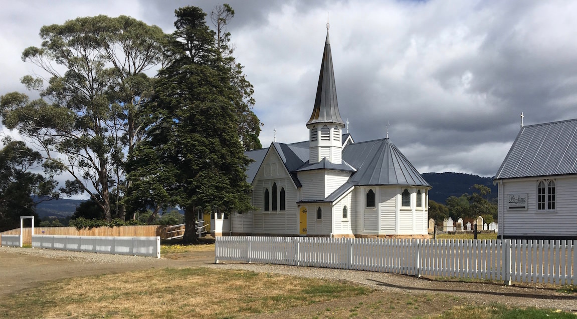
St Cuthbert's Church in Ranelagh
Huon River at Huonville
Boats at rest south of Franklin
Passing the baton to Batten
My turn to drive
Di's ride was just a bit longer than mine, but with slightly less elevation gain. Here's her route ...
Di's ride from Frankin to Southport
Along the way Di took this great snap of Adamsons Peak as she was leaving Dover ...
Adamson's Peak
... and this lovely snap of a clutch of boats tucked into a very quiet spot near Esperance ...
A quiet corner
While Di was nearing Southport I set up at the the camper on an unpowered site at the caravan park, and when she arrived we locked the bike's under the bed ...
Home sweet camper
We had a quiet afternoon drinking beer and reading. Then it was dinner and early to bed ... always early to bed in the camper!
Day Two: Walk to Lion Rock with a side trip to the Whale
The first thing to do was drive to Cockle Creek, where the South Coast Track finishes and the return journey to South Cape Bay begins. The latter is one of the 60 Great Short Walks of Tasmania and has, justifiably, become very popular. (BTW, the list of walks with directions, maps, etc is now available as an App from iTunes.) Here's what the route to Cockle Creek from Southport looks like ...
Southport to Cockle Creek
South Cape, that narrow bit of land jutting out into the sea at the bottom of the map, is the southernmost point on the Tasmanian mainland.
From Cockle Creek it is about 7 ½ kilometres to Coal Bluff, which overlooks South Cape Bay, and about another kilometre along the beach to the campsite at the other end and Lion Rock. This little corner of paradise is a popular destination for intrepid Tasmanian surfers who like their adventures away from the madding crowds at more popular beaches. there were four young lads with their tents tucked in behind the dunes at the other end of the beach when Di and I arrived and sat down to have our lunch.
But I'm getting ahead of myself. Here's a look at the route into South Cape Bay ...
Cockle Creek to South Cape Bay
Unfortunately, as you can see from the satellite image, there is a fair bit of clear-fell logging taking place right on the edge of the World Heritage Area. We - well mostly Di - took a few photos along the track ...
A Trio of Currawongs in a dead tree at the mouth of Cockle Creek
The sign for the track is a little way into the bush ...
It's this way ...
Initially the track is through mixed regrowth forest, but then gets into buttongrass and low scrub, where duckboards help keep one's feet dry when there has been a bit of rain about ...
As the coast gets closer, the soil becomes sandier and you get into some forest, with a couple of creek crossings ...
When we arrived at Coal Bluff, where the track bursts out of the forest and the ocean becomes visible, there was a group enjoying an early lunch ...
South Cape Bay
It was fairly overcast and across the bay Lion Rock looked somewhat menacing ...
Looking across to Lion Rock
... but almost immediately the sun came out and cheered things up. The waves breaking over the rocks below the bluff made for a pretty scene ...
South Cape Bay with Southwest Cape in the distance
... and Lion Rock itself became much more benign ...
That's better!
We walked along the beach to the other end where the rivulet comes out and enjoyed the view back towards the bluff ...
Looking back to Coal Bluff
... and had a closer look at Lion Rock ...
Lion Rock
Apart from the four surfers who bobbed up out of their campsite to say hello, we had this end of the beach all to ourselves. it was a pretty pristine and peaceful scene ...
There was a mysterious old piece of machinery lying in the sand that we hadn't seen on previous visits ...
What can it be?
After lunch we headed back to the base of the bluff where Di took a couple of photos of isolated bits of vegetation growing in cracks ...
Up the new, sturdy rock steps (which have replaced the rickety ladders) we went and back along to the start of the track.
Not quite fully done in, we thought it might be good to walk the kilometre or so along to the whaling memorial. Just a little way along the road there is a huge old flywheel which was used in the sawmill that once operated on the spot ...
A reminder of the early logging days at Southport
The purpose of the flywheel was to generate enough force to allow the saw blade to cut through the dense timber of the mighty Swamp Gums that once covered the landscape around Southport.
The site for the whaling memorial is quite picturesque and I really wished I had a good camera with me to better capture the scenery. Here is a view looking over to Adamsons Peak, which looks very different from this angle ...
Adamsons Peak in the distance
Swinging one's view slightly south and westwards, one can see the wonderful Pindars Peak and the Coxcomb Ridge on Mount LaPerouse ...
Pindars Peak
The whale sculpture is quite lovely ...
Once, this spot teemed with whales ...
... and I couldn't resist taking this close-up of its eye, barnacled eyebrow and all ...
Take a closer look
According to Di, by the time we got back to the car we'd walked 19.5 kilometres in a touch over 3 ¾ hours so we thought we'd probably earned a rest, a beer and an afternoon snack.
Day Three: Cycling Relay ~ Home to Hobart
It was my turn to take the baton. With a fair bit of wind overnight the canvas on the camper was good and dry so pack up happened nice and quickly. I had about 55 kilometres ahead of me, which I was quite looking forward to as I hadn't ridden the stretch of road from Southport north to Dover for perhaps 20 years. Unfortunately the wind had swung around to the north, meaning I was going to have to ride into it for the whole distance to Franklin. With cool temperatures, shade on the road and a climb of about 4 kilometres - albeit at a relatively benign gradient - to start with I felt it hard to hit my rhythm. Here's a look at the route ...
Southport to Dover
At least there wasn't much traffic on the road and the last part of the ride was relatively level. With the headwind I didn't feel much like stopping for photos but wanted to get a snap of this old Combie Van at the bodyworks on the southern edge of Geeveston ...
By the time I got to Franklin Di had her bike off the back of the camper. She wasn't quite ready to go so I continued up the road for a bit before looping back ...
Along the Franklin waterfront
With the biennial Australian Wooden Boat Festival - purportedly the largest wooden boat festival in the Southern Hemisphere - happening in Hobart over the past weekend and the Wooden Boat Centre located in Franklin, the town was quite busy both on both days we went through. Di was ready to go when I got back to her so I rode north about a kilometre with her to see her off then doubled back to the car again.
There has been an upsurge of apple growing in the Huon Valley and through to Cygnet, partly in response to the opening of of Asian markets and partly due to a growing appreciation of apple cider. A number of boutique cider producers have sprung up, including Frank's Cider in Franklin ...
Free Tastings!
At 45 kilometres, Di's ride home from Franklin was the shortest of our tour but the hardest as it had the most elevation gain. Here's what it looks like ...
Di's ride home
She was pretty happy by the time she got home, partly because she set a number of personal records, including some demon descending on the tight bends of Strickland Avenue ... and partly because I'd managed to park the camper on the shed (more difficult than usual because of a car awkwardly parked on the street) and get everything in from the car by the time she'd arrived.
And of cockatoos and kangaroos? Well, sadly the only marsupials we saw were dead on the road, particularly a proliferation of potoroos on the drive from Southport to Cockle Creek. On the other hand we were in a part of the state where Yellow-tailed Black Cockatoos abound, and heard lots of them calling around our camp in Southport and on our walk to South Cape Bay. And as I was leaving Southport a couple of them landed in a tree beside the road to farewell me.
We have covered a bit of territory since my last post. As the main reason for our visit to the North Island was to spend a bit of time with our grandchildren, perhaps a first up photo of Di with them would be appropriate ...
After leaving Gilgandra we made a beeline for the Queensland border so we could be close to Brisbane to pick up our little darlings. A search for camping not too far from Brisbane but also reasonably close to the Granite Belt of southeast Queensland yielded the Bigriggen Park, which boasts bush camping and a great environment for kids. We liked it so much when we arrived that we decided to book an extra night. Here's a photo of our camp set-up, with the kids' tent pitched under our bed (some might say a bit too close for comfort!):
The camping was great, with lots of room for the kids to run around.
We did one walk to the top of Mt Edwards from Lake Moogerah. Asha, full of beans, was the star of this walk, going to the top twice: once with me and once with Di. There wasn't a lot to photograph but I did make one picture of this interesting fungi which had grown around a leaf ...
From Bigriggen we moved to Stanthorpe for a couple of nights so we could visit Bald Rock National Park. (In retrospect we wished we'd gone to camp there, but we couldn't get any info on the camping and we thought, like the campgrounds at Giraween, it would be full during the school holidays.)
On the way through the Border Ranges we stopped for lunch at a little town called Bonalbo, where the kids also burnt off a bit of energy stored up in the car ...
Our little hike to the top of Bald Rock was fabulous, with wonderful views on a stunning spring day. Here's a photo of Di and the kids near the top of the peak ...
On the drive back we passed this amusing sculpture ...
A fantastic wind had come up by the time we got back to Stanthorpe so after lunch we got out the kids' kites and flew them both right out to the end of their strings. Asha and Zae were just a bit nervous about the kites being so high in the sky so we reeled them back in before they vanished into the stratosphere.
The next day we shifted to Girraween, where we had managed to snag just a couple of days at the end of our week with Asha and Zae. It was a scintillating day when we arrived so we wasted no time getting camp set up and then walking to the top of the Pyramid and back. We took a few photos along the way, but my favourite is probably this one ...
On our last full day at Girraween we hiked to the top of Castle Rock and then along to have a look at Turtle Rock. Although it was a bit showery and cool, the kids didn't complain at all and we had great fun scampering to the top of Castle Rock and tip-toeing back down dodging the puddles. As you can see if you look closely at the next photo, the spring flowers are starting to come out ...
The irises are especially beautiful just at the moment ...
After dropping the kids back at the airport we stopped in at Scarborough for a visit with our friends Max and Prue, enjoying dinner with them and their extended family. The next morning before leaving we went for brunch with them and Nev and Dot, who were also down in Tassie last summer for a "rendezvous".
While it would have been nice to join Max and Prue for an upcoming camping trip we really wanted to start our slow journey south and do a bit more riding in new territory, so we headed off across the border to Kingscliff. We had a terrific ride there through some lovely rolling terrain. You know you can only be in Australia when you see signage like this ...
Yesterday we moved further south to the quaint little town of Bellingen, where we are currently camped in the showgrounds. Today we had a very interesting ride. Some quite rough sealed roads; a bit of dirt; despite no long hills, quite a lot of up and down and then, finally, a lovely descent back into the heart of the town. Here's a photo of Di getting to the top of one of the hills on the gravel section of our ride ...
... and another of her relaxing back at camp reading a novel on the iPad ...
We hope to do another ride in the morning before leaving to head further south to our friends Graham and Liz in Bonnells Bay. The weather looks good, let's hope the legs are willing.
Here's a map showing the territory we've covered since our last post ...
We're not quite sure exactly where we're headed after Bonnells Bay, but we'll be in wonderful Wagga Wagga in a week and a half. How we get there remains to be seen ...
Well G'day. It's been a while since Cockatoos and Kangaroos has had an airing, but here we are.
It seems fitting to be making a post in this blog when we are on the road again with the Prado and the Ulti, on our way to pick up the grandkids for a bit of exploring in the backblocks of southeast Queensland. Hopefully we will be able to share some iconic Australian landscapes with them and have an outdoor meal or two, although - as we are not going to be on the coast - we probably won't throw on a shrimp on the barbie! Besides, it isn't actually summer yet so not technically barbecuing season.
After leaving home in Hobart at about noon on Sunday and then stopping to visit Pat and David in their new home in Longford, we rolled on to spend the night in Devonport before catching the morning ferry to Melbourne. All sweet until the silly sausage who checked our vehicle decided that the smaller of our camper's two gas bottles needed to come out of its secure storage locker and go on the trolley for us to pick up at the other end. Unbelievable. We've been back and forth on the ferry with the camper perhaps a dozen times and never had anyone query this before. The officious little person gave the official reason as "all gas bottles must be held in place by a metal bracket". So this is what we have in our gas locker ...
Secure or ... not secure?
As far as I know, none of the 40 or 50 Ultimate camper trailers that visited Tasmania last summer had to surrender their gas bottles for transport and, as I said, we've never had this happen before. Just another little bit of silliness from a small person with a very small brain. (Compared with all the other trips we've made over the years with camping gear stuffed into the car and always having to stop when we get off the ferry to pick up a gas bottle, up until now travelling with the camper-trailer has been sweet in this regard - which is why I was particularly annoyed this time around.) What made it all even more silly was the person with the official coat on did not insist that we had to surrender the big bottle, which has the same sort of restraint system as the tiny bottle. Why not, I wondered (but not aloud: didn't want to get the small brain working too hard!)
Landfall and beyond
This was our first ever day sailing on the Spirit of Tasmania and we had a general - but untested - plan of "What to do When We Get Off the Boat". The ferry arrives about 6:00 p.m. We wanted to clear Melbourne and get a bit of a way up the road so we could reduce - if only slightly - the amount of driving we would have to do each day for the next four days to a base from which we would sally forth to the Brisbane Airport to pick up our darlings. We've got the bikes with us, and our hope is to be able to have a ride after driving each day.
So far so good. Here's a map showing where we've got to so far: two days after landing in Melbourne and our target for midday on Friday ...
We got a couple of hours and about 170 kilometres up the road to Euroa: just in time to check into a motel (it was raining) to watch the final episodes of both Vera and The Bletchley Circle on our beloved ABS.
Now fully debriefed and ready for a month on the road - although I will at least have to find a pub to watch the AFL Grand Final - we set off yesterday morning with a vague plan to drive about 400 kilometres, find a caravan park and then go for a ride, then repeat a couple of times. Oh yes. We also wanted to drive some roads that we'd not been on before and visit some previously unvisited towns.
The First Stop is the ... Sweetest?
With Di looking at the road atlas as I drove, we cobbled together a route and fetched up a bit after midday yesterday in Young, which lays claim to being the "Cherry Capital of Australia", a boast that several places in Tasmania would find somewhat bemusing. It was a bit cool, but we really wanted to get back on our bikes after a pretty hectic month without much time turning the pedals so, after setting up the camper and changing into our cycling gear, off we set.
Now, Di hasn't been on the bike quite as much as me since we finished our ride from London to Rome so we were playing it by ear as far as the distance we would go. It was a bit cool and we only had a couple of hours of daylight left so ended up doing a shorter ride than we might have liked. Here's a photo of Di, stopped to put on her headband for a bit of extra warmth ...
A typical Aussie outback scene: gum trees and canola
Going Deeper into New South Wales
Without really planning it, our drive over the past couple of days has taken us through some historic places. Before arriving in Young yesterday we passed through Cootamundra, the birthplace of "Our Don", otherwise know as Don Bradman, the cricketer with the fabled batting average of 99 point 9 something (light years above anyone else in the history of the game). And today we passed through Grenfell, the birthplace of the great, but seemingly almost forgotten by modern Australia, colonial era poet, Henry Lawson. This is goldrush country and many of these towns boast a faded grandeur, thanks to the legacy of the precious ore extracted from the creeks and rivers that wend across the landscape.
During today's drive from Young to Gilgandra we passed through country that has had a lot of rainfall over the past few weeks. With the terrain hereabouts being generally fairly flat, when it rains a lot the water tends to wander a bit resulting in widespread flooding. We crossed through a number of spots where there was water across the road. Here's a video of one of those crossings, that Di shot through the windscreen of the Prado ...
Despite being slowed numerous times by these aquatic incursions, we managed to arrive in Gilgandra reasonable early in the afternoon, set up camp and set off for another ride. (Two rides together in two days: yippee!) Even on our ride, where we found a quiet road off the highway, we crossed several small watercourses across our path. There sure is a lot of water about. Which of course means that there will be a large upsurge over the spring and summer ... Of Cockatoos and Kangaroos! And with that I bid you all a good night ...